Wednesday, September 12, 2018 7:13:36 AM
Pine Tree Wind Farm
The LADWP's Pine Tree Wind and
Solar Farm lay's within the Western Tehachapi Mountains (I have seen
some maps listing this area as the Sothern Sierra Nevada Mountains). The
area stretches from the Jawbone Canyon and Jawbone-Butterbredt Area of
Critical Environmental Concern (ACEC) to the North Sky River Project and
the Jawbone Wind Energy Project to the West.
the southern extremity of the Sierra Nevada Mountains. A unique
mixing of several different species of plants and animals occurs
within the ecosystem transition between the Mojave Desert and Sierra
Nevada Mountains. Desert plants such as creosote bush, Joshua tree,
burro bush and shadescale may be found in close association with
pinyon pine, juniper, canyon oak and digger/grey pine. The varied
vegetation provides habitat for a great diversity of wildlife over a
small geographic area. Species of note include raptors, the
yellow-eared pocket mouse, a variety of lizards and a number of
migrant and resident bird species. This wilderness is part of a
National Cooperative Land and Wildlife Management Area and the BLM
Jawbone Butterbredt Area of Critical Environmental Concern, which
was designated to protect outstanding wildlife and Native American
values.
The quote above is from the Digital-Desert internet site which by
the way has a huge amount of information on many different facets of the
Mojave Desert area.
The text above concerns the Kiavah Wilderness
area which is just northeast of the Pine Tree Wind Farm area and has
much of the same terrain, geology, wildlife, plant life and climate. The
description serves the Pine Tree Wind Farm area well.
So in other words the area of Pine Tree Wind Farm is NOT some
desolate wilderness without plant or animal life. This area of the
Southern Tehachapi Mountains as with the Owens Valley has enough value
to all of mankind and needs to be preserved.
The behemoth that is
Los Angeles is cannot be allowed to continue to rob, rape and plunder
outside of it's own bailiwick. I am not stating that the Pine Tree Wind
and Solar Farm is in any form a ecological disaster as the Owens Valley
is today, but that the people of Los Angeles could and should examine
their own responsibility in the many different environmental mistakes
they continue to make.
In truth I found the LADWP's Pine Tree
Wind and Solar Farm to be very clean of trash, the road network limited
to what is necessary to maintain the wind turbines and solar panels, NO
graffiti at all, zero derelict vehicles and from what I could see no oil
spills! On all this and more LADWP should be congratulated.
So here are a few
photos to prove that this area is worth saving!
Black bears and Bobcats are known to habitat in this area! One would
think that simply by gazing at this photo only jackrabbits and lizards
could live in this area.
Wrong again!
One of the last photos before leaving was this hillside that was in
shadow. A rugged rocky area that has a diverse plant structure. I
believe a few of the trees are Blue Oaks toward the bottom center and
left. Heading up towards the rocks I believe those are Pinion Pine not
Juniper, but cannot verify that as I had no time to explore. Some Big Berry
Manzanita may be seen in the center.
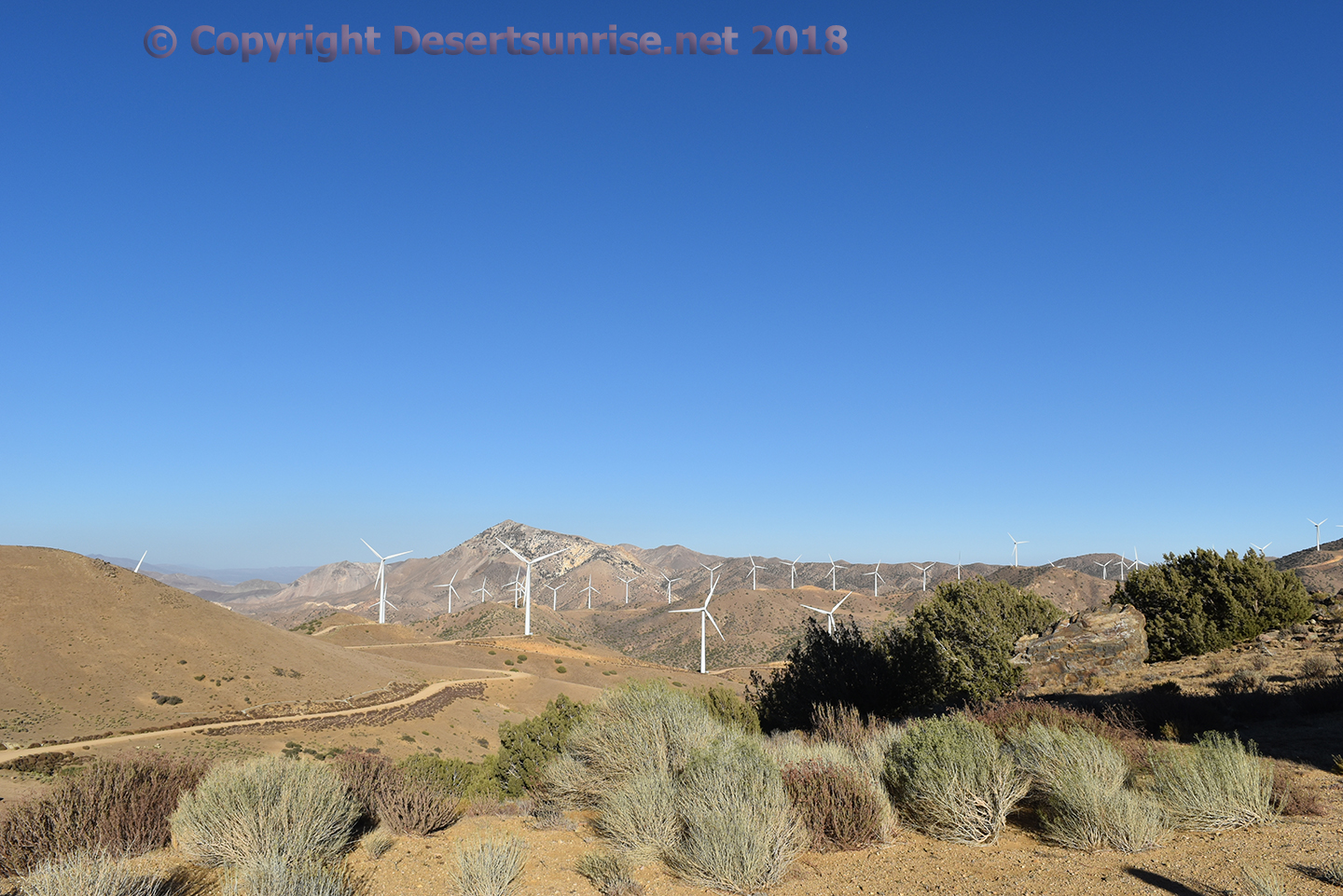
Ahhh back in the light! Interesting photo indeed! 1st you can see 18 of
the 90 GE 1.5 MW 1.5sl or 1.5sle wind turbines at work. All were working
at the time of the photo for a
potential of up to 27 MW's of electric
power.
In the near foreground are some California Juniper trees
and Sand Sage (probably not California Sage). The hills in the immediate
background are littered with mostly Pinion but some taller Juniper.
Now see the turbine blade just poking out of the hillside to the far
left, now gaze just to the right of that blade and look for a long white
line going horizontally across the hills. That's right, you guessed it,
it's the Los Angeles Aqueduct!
This scene above is undoubtedly due to overgrazing. But also notice
the
Mormon Tea (Greenish shrub, but is this
really Morman Tea or Sand Sage?) in the bottom of the photograph and how they are bending
away from the near constant wind. The wind itself makes it a little more
difficult for nature to re-populate the hills and valley seen here due
to the simple fact that seeds are blown by the wind and cannot easily
gain a foothold. Year after year of grazing eventually reduces the
vegetation to grasses.
The brownish shrubs are probably
California Buckwheat which is thankfully a native plant.
One of
the grass type is
Cheatgrass which is NOT
native to the North American continent anywhere! Much of the brown grass
was / is Cheatgrass.
Mormon Tea
(General: Ephedra Family (Ephedraceae). Green ephedra (
Mormon
tea) is a dioecious, scraggly shrub rarely more than 60 cm to 150 cm
high. The vivid green foliage presents a striking contrast to an
often-dull gray desert environment. It has been widely planted as an
ornamental. This species is used in seed mixtures for re-vegetating
depleted game ranges in the mountain shrub and juniper-pinyon types and
optionally in the sagebrush type in Utah.)
Information from:
http://mojavedesert.net/plants/shrubs/mormon-tea.html
The horrible invasive cheatgrass covers the immediate foreground
here. The larger bushes to the left could be California buckwheat. The hillsides to
the right seem to be a combination of Creosote and Pinion.
A well grazed hillside with copius amounts of well munched cheatgrass. A
1.5 MW GE wind turbine provides electric power to a hundred or more
houses and a couple of strip malls in Los Angeles. Above the well grazed
grassy area is a zone of Morman Tea, California Buckwheat and sagebrush,
but what else?
Open the photo to full size and you will see a small herd of California
Mule Deer. 2 does and a fawn. The fawn is kneeling down facing the
opposite direction from the other 2 mule deer. Can't see all 3? Go
Here.
The Mule Deer (
Odocoileus hemionus californicus) showing a white
tail with a black tip. The mule deer are not eating the cheatgrass, the
cattle are doing that chore.
Normally, the California mule deer
will prefer hill terrain over flatlands and plains, they especially like
oak woodland habitats. California mule deer browsers and typically take
about 90% of their diet from shrubs and leaves and the remainder from
grasses.
Here it looks like 4 doe and 1 fawn, all were moving in a easterly
direction. This is not the same group as in the photo above with the
mule deer under the wind turbine.
It was nice to see that the
area around the wind turbines still had a healthy environment as to be
able to support a deer population.
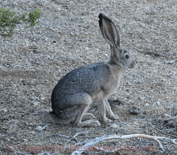
The
Black-tailed Jackrabbit
was seen all over the Pine Tree area. This mammal serves as a food source
for many raptors and bobcats plus as always in the West, a favorite Coyote
meal!
And this is a fitting end to our journey to the Pine Tree Wind and
Solar Farm in the Tehachapi Mountains.
If something is amiss in
this article you can always e-mail the Desertsunrise Webmaster fellow!
Just go up to the top at the navigation section to peruse other
Desertsunrise pages.
Top

Notice please that these 3 pages will all load just a little slower
than the normal slow loading Desertsunrise pages due to the heavy
graphic content.
Again no
CHUM pages
here!
The 3 pages are all linked at the bottom of each page. Just
a second or two extra wait!
Or you can watch "Bubblegum Head"
having fun with his head!
Operational Wind Projects Tehachapi Wind Resource Area, 2018
 Cheatgrass
Bromus tectorum, also known as drooping brome.
Cheatgrass was introduced to North America through contaminated
grain seed, straw packing material, and soil used as ballast in
ships sailing from Eurasia. This first occurred between 1850 and the
late 1890’s. During this time, abusive use of rangelands, coupled
with drought, left many Great Basin rangelands in poor condition.
Cheatgrass was able to occupy areas where the native vegetation had
been reduced, beginning its persistent march across the landscape.
Quoted from:
The reduction of native plants and the increased fire frequency
caused by B. tectorum prompted the United States Fish and Wildlife
Service (USFWS) to examine if the greater sage-grouse needed to be
listed as a threatened or endangered species due to habitat destruction.
After the review was completed by the USFWS, Secretarial Order 3336 was
signed with the goal of reducing the threat of rangeland fires and
preserve habitat by reducing downy brome.
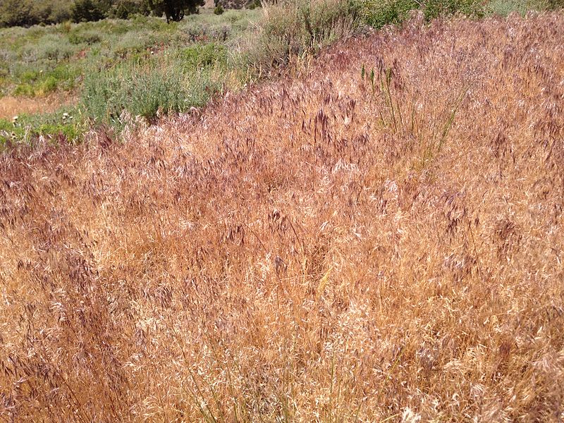
This is in June when the weed is ready to drop seeds and become a
wildfire hazard.
Cheatgrass has a nasty habit of having it's having grow area
(stands) dry out by mid-June and that makes wildfires all that more
likely to happen earlier in the season. Now these early to mid-summer
fires are very tough on the native forbs and grasses. So then the
Cheatgrass drops it's seeds prior to the fire season and if no fire
burns the Cheatgrass seeds they will germinate with any fall
precipitation.
This cycle gives rise to a dense, continuous
stand of Cheatgrass that makes additional fire hazards all that more
likely. Wildfires then return at quicker intervals that are less than 5
years under cheatgrass dominance. Western sagebrush plains used to have
natural wildfire of 60 or more years. Now with every new fire on a 4 or
5 year cycle the cheatgrass increasingly becomes more dominant and
continues to expands its range of infestation.
One method of combating
Cheatgrass is to have increased livestock grazing begin in early spring
as this helps to lower seed production and reduce fuel for fires if the
Cheatgrass is grazed to a stubble.
(from Wikipedia)
The black-tailed jackrabbit (Lepus californicus), also known as the
American desert hare, is a common hare of the western United States and
Mexico, where it is found at elevations from sea level up to 10,000 ft
(3,000 m). Reaching a length around 2 ft (61 cm), and a weight from 3 to
6 lb (1.4 to 2.7 kg), the black-tailed jackrabbit is the third-largest
North American hare.
Black-tailed jackrabbits occupy mixed
shrub-grassland terrains. Their breeding depends on the location; it
typically peaks in spring, but may continue all year round in warm
climates. Young are born fully furred with eyes open; they are well
camouflaged and are mobile within minutes of birth, thus females do not
protect or even stay with the young except during nursing. The average
litter size is around four, but may be as low as two and as high as
seven in warm regions.
The black-tailed jackrabbit does not
migrate or hibernate during winter and uses the same habitat of 0.4 to
1.2 mi (1–3 km2) year-round. Its diet is composed of various shrubs,
small trees, grasses, and forbs. Shrubs generally comprise the bulk of
fall and winter diets, while grasses and forbs are used in spring and
early summer, but the pattern and plant species vary with climate. The
black-tailed jackrabbit is an important prey species for raptors and
carnivorous mammals, such as eagles, hawks, owls, coyotes, foxes, and
bobcats.
There are six subspecies of mule deer (
Odocoileus
hemionus) in California:
- O. h. californicus - California mule deer (Westside of
Sierra Nevada down to southcoast)
- O. h. eremicus - Desert/burro mule deer (southwest
California, northwest Mexico and Arizona)
- O. h. fuliginatus - Southern mule deer (Southernmost
California and Baja California)
- O. h. hemionus - Rocky Mountain mule deer (Northwest
California, western and central North America)
- O. h. inyoensis - Inyo mule deer (Sierra Nevada, California)
- O. h. columbianus - Columbia Black-tailed deer (Northern
California and Pacific Northwest).
The Inland Deserts Region has four of the six mule deer subspecies:
the Rocky Mountain and Inyo subspecies in the north and the California,
Southern, and Burro subspecies in the south.
The mule deer
(Odocoileus hemionus) can be recognized by its large ears (mule-like)
and black tipped tail.
Deer are generally crepuscular, foraging
activity occurs mostly around dawn and dusk, but deer may be active day
or night depending on other variables, such as human activity or other
disturbances in the area.
Deer diets differ across their range, but high
quality digestible forage is selected when available. Not all plants are
nutritious for deer. Deer feed on grasses and forbs in the spring and
summer, however they are primarily browsers. High quality forage items
like young tender shoots, young shrubs, leaves of plants that are high
in nutrients, succulent grasses, and forbs are selected. Also, deer eat
items such as bark, buds, and acorns.
In the high deserts and chaparral,
some common plant species that deer forage are: bitterbrush, sagebrush,
blackbrush, ceanothus, and mountain mahogany. In the diets of desert
mule deer, Marshal et al. (2006) identified 34 plant taxa, including
desert-ironwood, mesquite, brittle-bush, palo verde, burro-weed, and
wild buckwheat.
Here I have circled the 3 deer. One was laying down and difficult to
spot.


