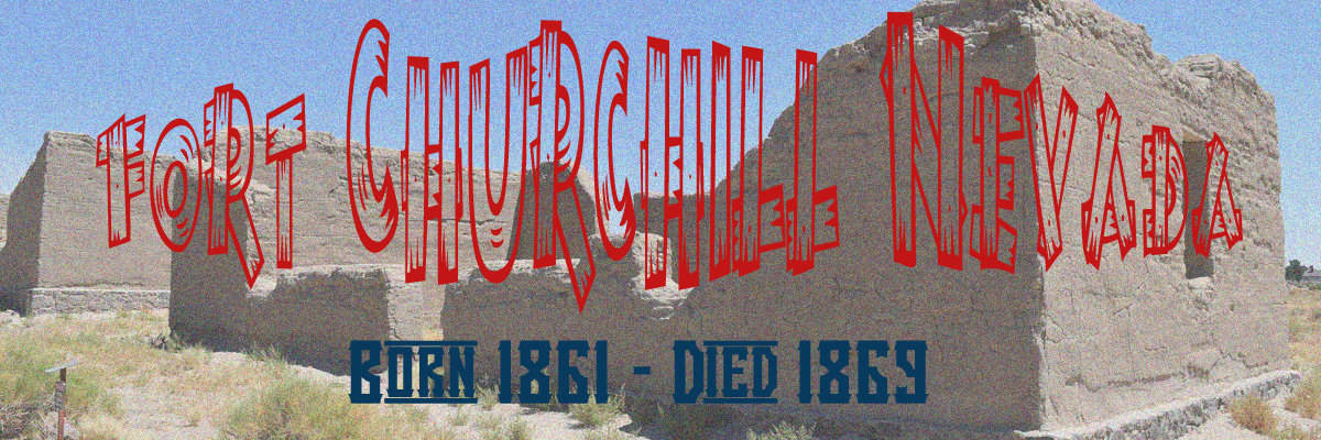
Finally the destination is at hand. Historic Fort Churchill! This
fort served it's purpose for only a few short years but those years were
colorful ones indeed! The spark that lit the fire has already been told at
the beginning of this set of web pages. Go back to the entry point if you
came into this tome from a "side road" by clicking
Here. This
action will not close this page but will open up the
Index Page in
another tab.
Anyhow here is a quick recap on how the fort was
created:
Captain Joseph Stewart and his Carson River Expedition were then ordered
to establish a post on the Carson River. Starting July 20, 1860, tens of
thousands of dollars were spent to construct Fort Churchill, the desert
outpost that guarded the Pony Express run and other mail routes.
Hundreds of soldiers were based here between expeditions against the
Indians.
The fort was named in honor of Sylvester Churchill, the
Inspector General of the U.S. Army. It was built as a permanent
installation. Adobe buildings were erected on stone foundations in the
form of a square, facing a central parade ground. The Civil War made the
fort an important supply depot for the Nevada Military District and as a
base for troops patrolling the overland routes.
Fort Churchill not only served as a buffer against further local Native
attacks (Paiutes, Shoshone and Bannock tribes) but also to help protect the
short lived Pony Express, the Butterfield Overland Stage Company, miners and
eventually to become a base for the Union Army in the Nevada wilderness.
The actual construction of the fort must have been quite an undertaking
as the transcontinental railroad did not yet exist (Oddly enough, the
transcontinental railroad would open the same year as the closing of Fort
Churchill, 1869). This meant that and construction materials that could not
be found locally had to be either brought across the same emigrant trail as
what the pioneers were using or to be shipped from the east coast cities to
Panama and then up to California by another ship and then transported by
mule teams or oxen carts over the Sierra Mountains to the construction site.
Most of the fort was therefore constructed of timber, either local
Cottonwood or Ponderosa Pine from the slopes of the Sierra Mountains and
stone (I wonder if Mr. Basalt was used in Fort Churchill?) and
adobe. Yes adobe, copious amounts of adobe bricks due to the simple fact
that adobe bricks could be made onsite using un-skilled labor.
I
cannot locate any information on whether or not native labor was recruited
in making the adobe bricks. In Spanish Central and South America native
labor was used quite frequently in construction projects such as for
missions, forts and other buildings, but those native laborers were nothing
more than slaves. Even though a mere 45 to 60 miles away up in the
Comstock Lode
mines were being dug and massive amounts of timber being cut and used to
shore up the mines. Also during the same time frame as the construction of
Fort Churchill towns like Dayton, Virginia City, Carson City were all
booming due to the discovery of silver in the Comstock Lode. So with this I
am sure that craftsmen like masons, carpenters, blacksmiths were already in
the area when the fort was constructed.
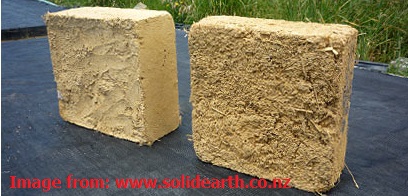
Adobe bricks (mud bricks) are made of earth with a fairly high clay
content and straw. If produced manually the earth mix is cast in open
molds onto the ground and then left to dry out. Adobe bricks are only
sun-dried, not kiln-fired.
Adobe brick building is an ancient
technique common in the Americas and the Middle East. The oldest
structures in earth dating back to at least 8300 BC are in adobe, as
well as some buildings around 900 years old, which are still in use.
"Adobe" is the Spanish name derived from the older Arabic "al-tob",
dating from the Moorish occupation of Spain.
Information from: www.solidearth.co.nz
The word adobe has existed for around 4,000 years, with relatively
little change in either pronunciation or meaning. The word can be traced
from the Middle Egyptian (c. 2000 BC) word dbt "mud brick." As Middle
Egyptian evolved into Late Egyptian, Demotic (Egyptian), and finally
Coptic (c. 600 BC), dj-b-t became tobe "[mud] brick." This was borrowed
into Arabic as al tob, tuba, or Al-ţŭb.[ (al "the" + ţŭb. "brick")
"[mud] brick," which was assimilated into Old Spanish as adobe [aˈdobe],
still with the meaning "mud brick." English borrowed the word from
Spanish in the early 18th century.
An adobe brick is a composite
material made of earth mixed with water and an organic material. The
soil composition typically contains sand, silt and clay. Straw is useful
in binding the brick together and allowing the brick to dry evenly,
thereby preventing cracking due to uneven shrinkage rates through the
brick. The most desirable soil texture for producing the mud of adobe is
15% clay, 10-30% silt and 55-75% fine sand.
Information via Wikipedia
To see a modern version of Adobe Brick
making, head over to:
http://desertphile.org/adobe/brick.htm. This page also has some
interesting points on testing adobe bricks.
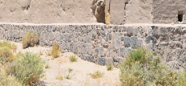
It seems that much of the
foundation for the adobe buildings in Fort Churchill was stone and I think
Mr. Basalt was
used extensively in this effort. Here is why:
Look at the foundation of this building in Fort Churchill. Do those stones
look like basalt or what? Remember we passed Susan's Bluff just a few miles
back on the Fort Churchill road. So we know that basalt was nearby and in
great abundance.
Also it would be helpful to know if the US Army used the labor
of the Calvary soldiers that Captain Joseph Stewart had taken from
California to this Carson River post. The reason I ask is that if so, then
maybe some of the soldiers in his company has stone mason experience as much
of the stonework seems professional.
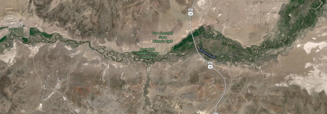
There is more to this area than
just the fort itself. Such as the Buckland Station, a ranch house, a hotel
and a way station for the Pony
Express. This house used timber from the Fort Churchill buildings when the
fort was closed and Mr. Buckland purchased the entire fort for $750.00!
Also the area has camping grounds and when the Carson River has a decent
flow you can canoe and fish. But we are here to see the remains of the fort.
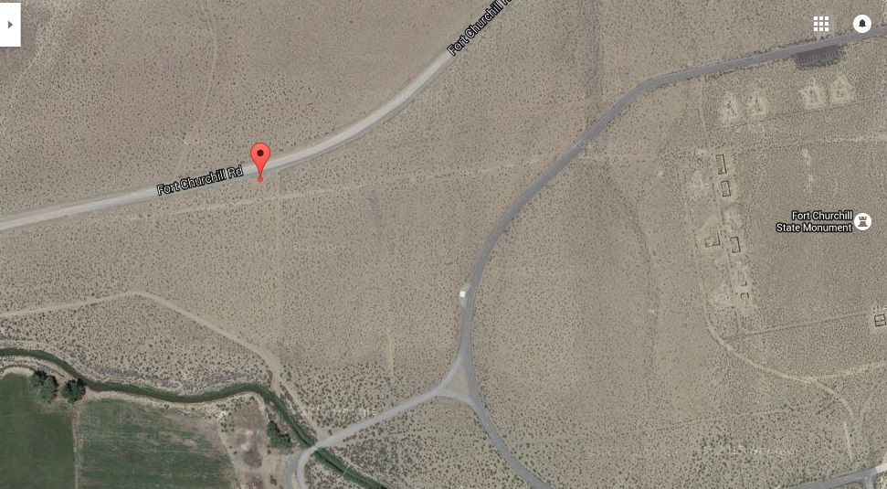
The satellite image on the right will give you a better understanding of the
area. The green belt follows the water of the Carson River. This is a
Riparian Zone that we
looked at earlier when we were further back the Fort Churchill road.
Some things are just not sacred anymore. Who marked up my satellite
image with crayons?

Anyhow, the Nevada State Parks has a brochure available on their website
or you can just
Click Here and it
will "
magically"
appear. The Visitor Center has some cool historical displays so don't bypass
that building. You will be asked to stay on the marked trails and to NOT
enter the buildings as they are deemed not safe.
Funny, I remember as a kid of maybe 8 or 9 years of age having visited the
park and remember walking in and out of the buildings playing a
hide-and-seek game with my sister. Well, either I am remembering the event
correctly or we were one totally illegal family. But then again considering that
this took place back in the mid 1960's, I still believe it is was very
plausible.
Why were as kids allowed to run through the buildings?
Most likely the park ranger or house guard had actually served with the US
Calvary in the 1860's and did not finally retire until the 1960's. Maybe his
last post was guarding the fort from pesky little boy's chasing their
sisters in and out of the barracks! Sure, maybe he had lived to see a hundred and
twenty-five birthdays! Well now, so do you still believe in magic?
OK! Moving
on.
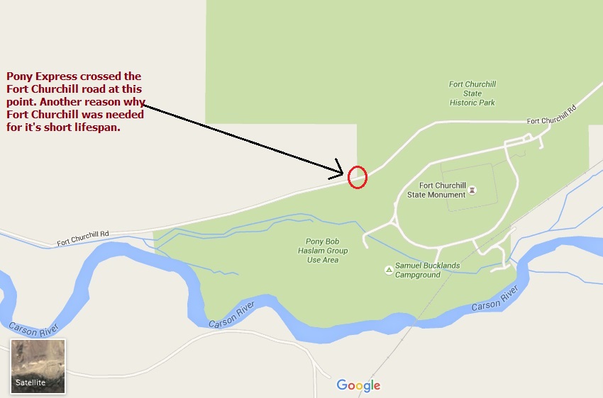
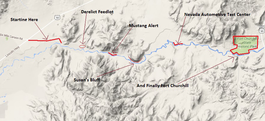
One of the first signs you will see by using the Fort Churchill road
is the Pony Express sign indication a point where the Pony Express route
crossed the Fort Churchill road. This is just before the dirt road turns
into asphalt road! Not much to see of the trail today but I am sure if you
walked a mile or so to the West you might find more of the original trail.
On the right is a map of the location in relation to Fort Churchill.
And below is a Satellite image of the crossing location. The GPS location I
have for the crossing point is: 39.292939,-119.278061.
Below right is a photo of the sign post
denoting the actual
crossing point of the Pony Express route and what is now called the Fort
Churchill road. You can easily see that the Pony Express route was virtually
in view of Fort Churchill. I am sure that for the riders coming in either
direction the fort was a welcome sign. But even more so for those riders
coming from the east as that portion of the Nevada route was a lonely ride.
The Paiutes, Shoshone and Bannocks may have viewed the fort in an entirely
different manner, something more like "
crap,
there goes the neighborhood"!
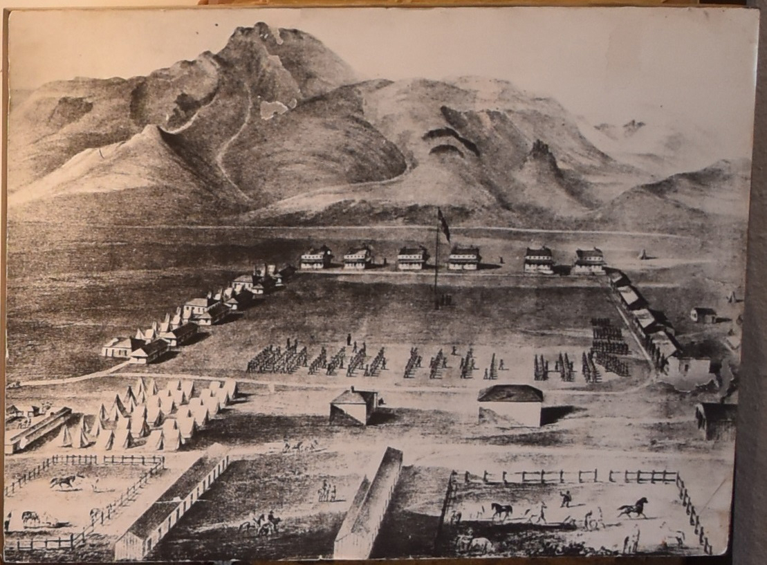
I have not seen up to this date (7/14/16) a single photo of the fort taken
during it's operational period! If any photo survives of the fort when the
US Calvary occupied the fort, that photo would be invaluable to history.
But in the visitor center of Fort Churchill a large painting is
available for viewing showing the fort from an artist's conceptional idea of
what the fort looked like during it's operational period of 1860 to 1860.
But I went to the adobe buildings first as I did not want to loose the
remaining sunlight.
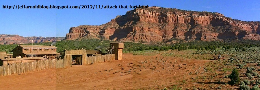
Another very interesting fact about Fort Churchill is that it was never
walled or enclosed! I used to believe as a child (due to the Hollywood
fantasy machine) that all Western American forts looked like Fort Apache or
Fort Yuma from some Hollywood film set.
"Of course, forts were usually shown as wooden palisaded structures and
Indians often attacked them. If you've ever visited any real forts in the
West you know they weren't like that at all. They were more open, adobe- or
stone-built military bases. Fort Apache, NM or Fort Laramie, WY for example,
are great places to visit today. You get a real sense of what it was like.
Forts became central to the Beau Geste genre (Saharan Westerns, really)
and other types of film. Many were filmed at Kanab Movie Fort in Utah."
A quote from:
http://jeffarnoldblog.blogspot.com/2012/11/attack-that-fort.html
On your right is a photo of a Hollywood movie set in Kanab,
Utah. Typical idea of a western fort for the B-grade Cowboy/Indian/Calvary
films of the 1940's and 1950's.
Compare the Hollywood fantasy fort on the right to what remains of Fort
Churchill on the left. I too watched all those Western themed films of the
created from the 1940's to the 1960's every weekend as a child growing up
only a few dozen miles from this same fort! And yes for a point in time I
thought all the Calvary forts looked like the fake one above.
Now back to some reality.
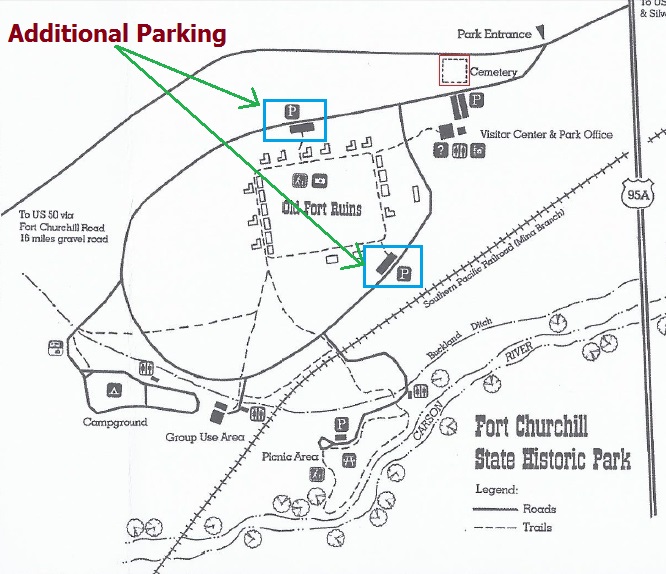
One of the first areas you will probably see when you get to the fort
(unless you head for the visitor center or rest rooms) is going to be the
cemetery. Marked in red in on the map at right in the upper right corner.
Note that you do not have to park in front of the cemetery or in the
visitors center parking as you can see from the map in green 2 other
additional parking areas closer to the adobe structures at Fort Churchill.
As was stated earlier the soldiers graves
were removed back in the mid 1880's to Carson City. The existing graves now
in the cemetery are those of the Buckland family who ran the Pony Express
way station, Butterfield Overland stage depot and provide (sold) fresh
vegetables and probably alfalfa to the commissary at Fort Churchill.
The cemetery does not seem very large in size, but then again the fort was
only occupied by the US Calvary for 8 to 9 years. Some of the headstones
have cracked and shifted over the years since the occupants were buried
here. Considering that Mr. Buckland had purchased the fort after the Army
had left, he could use the cemetery as he wanted minding not to disturb the
soldiers graves.
These are the known graves in the cemetery at Fort Churchill:
Buckland, Ann, no dates, (infant)
Buckland, Charles Adelbert, no
dates, aged 8y, 8m, 4d, s/o E.A. & S.S. Buckland
Buckland, Eliza Ann
Prentice, d. 3 Jan 1884, aged 43y, 4m, 2d, w/o S.S. Buckland
Buckland, Eliza, no dates, aged 2 days
Buckland, Samuel Sanford, d.
28 Dec 1884, aged 58y, 3m, 15d
Buckland, Samuel Theodore, no dates,
aged 2y, 9m, 2d, s/o E.A. & S.S. Buckland
Buckland, Sanford William,
d. 1 Feb 1865, aged 1y, 8m, s/o E.A. & S.S. Buckland
Burrier, Daniel,
d. 20 Jul 1876, aged 35 yrs
Simply Wow! The oldest person in this cemetery is 58 years old and
the youngest in age is 2 days! Was pioneer life rough? Thoroughly YES! And
these dates prove it. A rough average here is 16 years. This was only about
130 years in our recent past history.
The fort is left in a state of historical decay or natural decay
similar to the famous California ghost town of Bodie. In other words the
buildings are left in the same condition as when the as normal aging of any
building will have, no re-building of any portion of the barracks, mess hall
or offices.
This has 2 effects, it gives the historian, researcher,
tourists and camera toting road warriors like me a chance to examine a
historical accurate set of structures. This site IS NOT a tourist trap and
thank God for that!
The other effect is for people who are used to the fake tourist trap
locations and expect to see a near perfect replication of Fort Churchill
with all the buildings re-built to represent what the fort might have looked
like in 1861.
Gross! I can
travel down to Disneyland and hang out in "Frontier Land" to have that
fake feeling. I am not trying to disrespect Walt Disney's creation, just
separating fact from fiction so if any reader of these pages visiting
Historic Fort Churchill will not be disappointed if they were in fact
expecting a typical tourist trap recreation of a Wild West Cavalry fort with
John Wayne greeting them.
Something I did not know about the fort
that leaves me wondering. The dirt covered floors! Bummer man. One would
think that at the least some of the adobe bricks could have been laid down
as a floor. Just 50 miles away in Virginia City (now a tourist trap, but
fun!) the saloons all had wood floors. The hotels probably all had wood
floors covered with rugs!
I mean to say how do you sweep a dirt
floor for inspection? I spent some time in the California Army National
Guard and while in the Active Army for training we had weekly barracks
inspections and drill sergeant walk through every day.
I can just imagine the scene from 155 years ago:
"Reporting as ordered sir" "Soldiers barracks ready for inspection sir".
"Fresh straw from the stable for our bedrolls and the dirt floors have been
swept and mopped sir".
Captain Sagebreath answers "Mopped the floors did you say private?" "Private
Rocky Basalt, you are drunk, report to the stockade"!
During the 1860's the typical soldiers diet consisted of
beef, beans, saltpork, coffee and some condiments such as sugar, salt,
vinegar and molasses. Whoa, wait a minute here! Vinegar was and is to never
is to be considered a "condiment".
Hold on a minute here, did we not read
earlier that the Buckland's sold fresh vegetables to the fort. I think that
the sign narrative was speaking of soldiers in general throughout the USA.
The US Army in the second half of the 19th century let most of the far flung
posts (to a politician, Washington DC is the center of the world and the
further you go west from DC the further into the barbarian lands you were.
Depending on the distance from the fort and level of corruption of the
quartermasters, other food such as barrels of potatoes, apples, onions,
eggs and butter could also reach the soldiers. However, shortages were
usually such that the troopers were forced to supplement their diet
through purchasing or stealing food, cultivating small gardens and
hunting. After 1880, tinned food appeared, which facilitated the supply
of food and led to an improvement in the diet.
Quoted from the book:
The United States Cavalry 1865 - 1890
Patrolling the Frontier
by A. Mayoralas
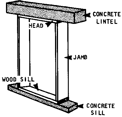
Building Labeled as the
Powder Magazine. Not sure which building is the real magazine!
This building on the right did not have a plaque next to it so I do not
know what it was used for. But it does seem to have a different construction
type than many of the other buildings.
Notice the small window type
opening at the top of the structure and the lintel (cross beam) on the
bottom.
This is quite different from normal construction methods.
The only building I can think of at Fort Churchill that might
have this type of construction is the Powder Magazine which did not have
windows but needed ventilation.
This was the era of
Black Powder
before modern nitrocellulose powder came into use. Black Powder had to be
kept dry and away from any spark, hot ash from camp fires and from the
soldiers smoking who might carelessly throw a burning match and boom, half
your fort just got wasted.
And even worse, you had NO gunpowder to
use against those pesky Indians and ruthless drunk bandits!
Watch were you step on the pathways. And
especially if you are camping down by the Carson River! Rattlesnakes love to
swallow rodents and rodent love your leftover food and garbage.
Western Rattlesnake (Crotalus oreganus)
A habitat generalist and
widely distributed over the western United States, it is represented in most
of Nevada by the sub-species known as the Great Basin rattlesnake (C.o.
lutosus). Its coloration is variable, but consists of primarily browns and
grays. Facial stripes can be faint to pronounced.
With exception to
localized overlap with the other rattlesnakes of southern Nevada, the Great
Basin rattlesnake is the only one inhabiting the northern two thirds of the
state.
At Fort Churchill the local lockup was called a "guard house" and not a stockade.
The word stockade also refers
to a military prison in an army camp, and in some cases, even a crude prison
camp or a slave camp. In these cases, the stockade keeps people inside,
rather than out.
The usual punishment for mild breaches of
discipline was confinement, being assigned barrack tasks, among other
punishments.
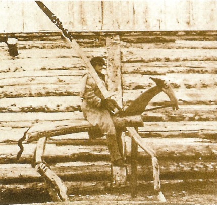
In the photo below titled 'Moral Session Horse' taken at Fort
Brigger, Wyoming, the soldier had to remain in this position holding the heavy
wooden sabre for a given period of time as punishment for having broken some rule.
The placard in the right photo confirms some of the information stated
earlier in the page at too where the construction materials came
from. Lumber from the nearby (approximately 50 miles) Sierra Nevada
mountains, nails, plaster, windows and hardware came over the Sierra's. I
have also received information that most of the clay for the adobe came from
the Carson River while the correct type of sand was to be found nearby.
Again I wonder why the dirt floors were never covered with rock or adobe
(although I understand adobe does not wear well) or even with rough cut
Cottonwood planks!
As you can see the pathways between the buildings is fairly level and
even so I believe most people should not have an issue getting to see all
the structures and their are NO stairs to climb in this area!
As
always in summer and late spring/early fall be mindful of the heat and drink
plenty of aqua and blah blah blah. So I sound like your nagging neighbor.
Well listen to him when it comes to safety.
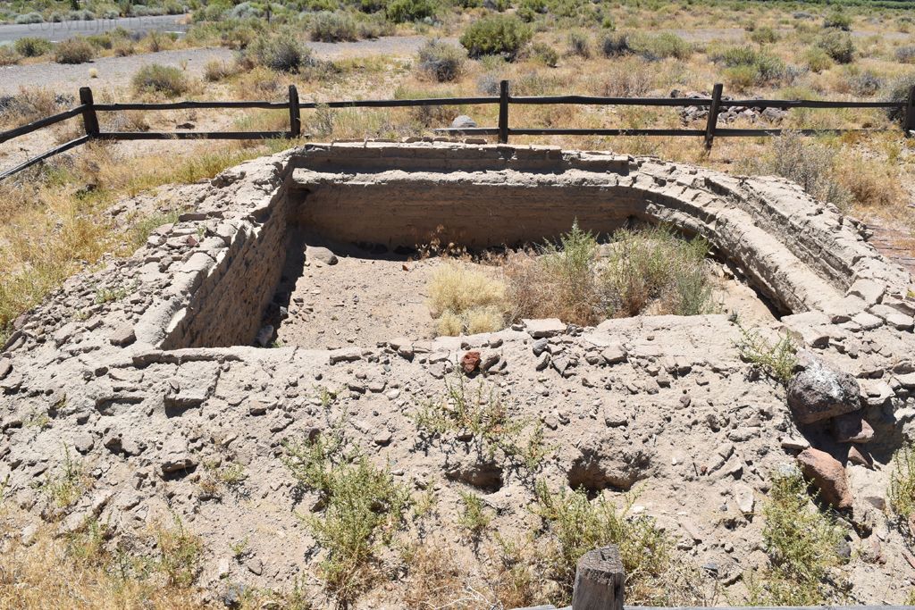
Now for a mystery structure. The photo to the right and the bottom
is of a structure that had no placard available to explain what it's
original function was. I am guessing a water well. Sure the Carson River was
only 400 to 500 feet away but during spring the runoff was heavy and the
water very heavy with sediments.
Having a well within the fort
structure also meant easier access for the soldiers and probably cleaner
water. Remember that most likely the soldiers washed their steeds in the
Carson River and the cattle in the area would also leave copious amount of
droppings in or near the river whenever that came down to the river to
drink.
Well water good! River water bad!
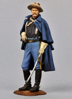
The cavalry soldiers of the Indian Wars era will always be remembered
for their bright blue uniforms and yellow neckerchiefs although, in
reality, the uniform varied greatly from this stereotypical image. The
soldier's uniform was somewhat more 'personal' and the reasons for this
are easily understandable: In the first instance, the isolation of the
various forts inhibited contact between disparate units and delayed
supplies. Secondly, the quality of the uniforms was very poor and didn't
stand up to the harsh climate. During the Indian Wars, four uniform
regulations were in service, corresponding to the years 1861,1872, 1882,
and 1888, along with a number of uniform instructions called 'General
Orders'. The surplus uniforms from the Civil War marked the first period
of the Indian Wars, poorly finished clothing that had been produced in
vast quantities. From 1872, the quality improved, but the new uniforms
didn't reach all the garrisons and when they did, any attempt at
harmonization clashed with the individual soldiers' already embedded
custom of dressing according to his preferences. While the stylized
'blue solders' were evident, they were mixed with a colorful blend of
military clothing of different production date, complemented with items
of clothing of civil and even Indian origin.
Quote from: The
United States Cavalry 1865 - 1890 Patrolling the Frontier
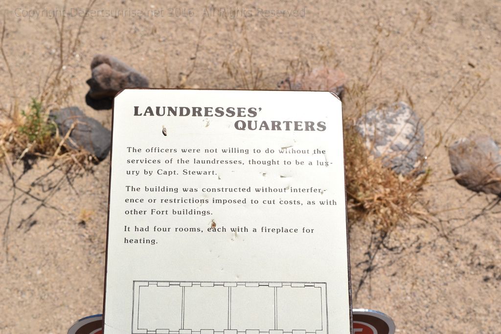
Remember these are the living spaces for the
"laundresses" and not the laundry itself. Was their a separate laundry
building, I don't know! So does the fact that there were 4 rooms indicate
that up to 4 women were employed as laundresses? Were the laundry ladies
paid by the US Army (doubtful) or by the officers out of their own pocket?
Did the enlisted men also use the services of these laundry women or did
they have to wash there uniforms in the horse trough?
Not enough time or room for all the photos so let's head up to the visitors
center and see what is on display.
Cool! Outside is a pair of ancient
(well really old) civil war era cannon. Here the techical name is given as
3-inch Ordnance Rifle. That gives us 2 peices of information right away;
1. The bore size is 3 inches or 76 millimeters.
2. The cannon is
rifled and not a smoothbore.
| Name |
Tube |
Projectile
(lb) |
Charge
(lb) |
Velocity
(ft/s) |
Range
(yd at 5°) |
| Material |
Bore (in) |
Len (in) |
Wt (lb) |
| 3-inch Ordnance Rifle |
wrought
iron |
3.0 |
69 |
820 |
9.5 |
1.00 |
1,215 |
1,830 |
The 3-inch (76 mm) rifle was the most widely used rifled gun during the
war. Invented by John Griffen, it was extremely durable, with the barrel
made of wrought iron, primarily produced by the Phoenix Iron Company of
Phoenixville, Pennsylvania. There are few cases on record of the tube
fracturing or bursting, a problem that plagued other rifles made of brittle
cast iron. The rifle had exceptional accuracy. During the Battle of Atlanta,
a Confederate gunner was quoted: "The Yankee three-inch rifle was a dead
shot at any distance under a mile. They could hit the end of a flour barrel
more often than miss, unless the gunner got rattled."
We have to leave now. I hope you enjoyed the "Road Less Travelled" detailing
"The Road to Fort Churchill".
Guess I will have to use one of those
old paper map thingy's because the Alt 95 to the 95 south going through
Schurz, Hawthorne to Mono Lake if California can have large areas without
cell phone reception so no Google Directions.